Before departure:
My destination in March was to be the central area of Brecon Beacons National Park in South Wales. The first day of the 2 days long trip brought blissful spring weather, while the 2nd faithfully followed the forecast wind and rain, hence both gave really different experience. On the first day I could move about in t-shirt and sit by a waterfall to catch the tender sunshine while the second was perfect to test the equipment. I used my car this time that served as sleeping area and this was amazingly luxurious compared to sleeping in a tent. My companion for this hike was my dog, Pulcsi.
The route was as below:
Summary (Ordnance Survey):
Distance: 48.86 km
Total elevation: 3096.4 m
Interactive map:

The route was as below:
Summary (Ordnance Survey):
Distance: 48.86 km
Total elevation: 3096.4 m
Interactive map:
The trip, 1st day:
Daily summary (Ordnance Survey):
Distance: 26.45 km
Total elevation: 2253.0 m

I drove up to Brecon Beacons the night before and we spent the night in a car park by the edge of the woods a couple of kms north of Pontsticill. The following morning we woke up around 5:30 am fresh and ready for the day's hike.

Pulcsi surveyed the area from the top of the table after waking up.

We just woke up and the Moon was calling it for today... or tonight to be more precise.

Making a phone call to home was our first task of the day and to do that we had to climb 3/4 of the hill beside us. The path lead along the watercourse of Nant Bwrefwr.

We already got high enough to get mobile service.

In the meantime even the sun rose.

We had a chance to marvel at the half dozen waterfalls on the way back to the car park.


Pulcsi is peeking out in the middle to give you an idea of scales.

From the car park down to Caerfanell river at the bottom of the valley we passed a dozen of new waterfalls.


10 metres long pine trees sticking out from the bottom of the waterfall.


The path was often difficult to follow so we rather chose to meander along the watercourse most of the times instead.


At the confluence with Caerfanell river. From here on we were to follow it up to its source for the next 3 hours.

On the way we passed several brilliant waterfalls, some of them with a really decent size.


Pulcsi was awestruck by the wonderful area too (even though she admitted later there weren't nearly enough squirrel and bunnies.)


This was the last of the big waterfalls on this section of the river but the biggest one was still ahead in the form of a cascade of waterfalls on Blaen Caerfanell in the hillside.


Grazing pony.


Pulcsi sat atop a slab of rock to have a look around.

Sheep and the waterfall on Blaen Caerfanell.

We decided to skip herding this time.


Still life of the hillside.

The aforementioned grand waterfall cascade.


We spent a lunch break on the terrace in the middle and topped it with a bit of sunbathing.

Pulcsi is enquiringly watching me on the 89% uphill slope to find out how far I still intend to go.

We haven't seen a soul today since we left the car park but all things good must come to an end. On the crest of the hill ant sized people started to appear.

We reached the plateau's edge where the path crosses Blaen Caerfanell.


The ford.

Frog eggs on the highland. We were trying to avoid running over their parents yesterday evening on the last section of the road by the reservoirs.


Above everything ... well, the valley at least.

Raven.


You could still come across snowy patches up here.

Beyond the peaty highland you could already see the peaks representing today's halfway point, the highest point in South Wales, Pen y Fan among them.

Caerfanell river's valley.

Path along the edge. Peaty moorland in the background is something that we came to experience from aclose in the late afternoon.

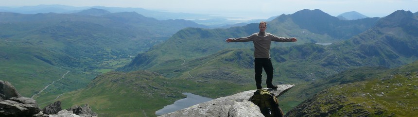
The summit of Pen y Fan at 886 m. Even from here, 5 kms away you could see it was bustling over there.

We were still a pleasant distance away from that traffic jam for now. The 3 famous peaks in the distance: Cribyn, Pen y Fan and Corn Du the furthest away.

An other rocky cliff.

The plateau.

We had a siesta at this spot.

Now the 4th peak is visible too by right edge: Fan y Big, the nearest of them all.


The path follows the edge of the plateau so you can marvel at the enormous valleys.

Just like Cwm Oergwm. Cwm is supposed to mean narrow valley, so I would rather put this one into an other category with its km long width.


A closer look of the peaks: Cribyn: 795 m

Pen y Fan: 886 m

Corn Du: 873 m

A rather dry reservoir.

Frog eggs and distant peaks.

Stone shelter.

Spring board of Fan y Big (719 m)

Hikers etched into stone.


Upper Neuadd reservoir.

Towards Cribyn.

Pen y Fan in the background.

Cwm Cynwyn valley.

On the summit of Cribyn.


In the saddle between two peaks.


A short rest halfway uphill.

There was a 20 metres long queue for the Pen y Fan cairn at the summit ... we didn't bother stopping here.

The stone at the summit.

Gliding raven over the rolling hills.

The path already walked is mostly visible along the edge of the plateau.

We had a stop between these 2 peaks too, just a few metres below the busy path on a quiet and windless ledge.

The busy path towards the summit, just above our heads.

Corn Du's side.

In Cwm Llwch valley the pond is called Llyn Cwm Llwch.

The local giant monster started thinking if she should eat at least part of all these people, but eventually she decided to stick with her usual diet.

Corn Du's summit.

Herds of people are streaming from the Storey Arms car park towards the summit.

Looking back towards Corn Du.


Passing Corn Du we headed south leaving the busy bit.

Raven walked by hikers.


About a km away we started to descend just as the Nant Crew river did.

Red kite.

By this time even a few seconds of a stop was worth for Pulcsi to lay down to rest.


Nant Crew river...

...and its valley.

The water of this waterfall got partially blown back by the wind.


Following the river we came across the usual amount of waterfalls.

It was tough going through this terrain scarred by many gullies. Walking in the hillside we crossed to the other side of the river from time to time and used the drier rocky parts of the riverbed where possible.


On the small island the ruins of a structure were visible, presumably something to do with sheep.


Far away wind turbines.


The lower section of the valley we didn't get to explore.

Passing the 4 bigger gullies in the east side of the valley we started to climb uphill.

We haven't seen any drenched sparrows just a bumblebee instead. (This actually makes sense in Hungarian... well, maybe not.)


210 metres higher we reached the lip of the valley and the plateau beyond proved to be serious moor indeed.


Huge, luscious pillow of moss.

Under the vegetation with the same pleasing shade of green water awaited the careless. Fortunately I realized this before dusk started to set in.

Peat bed.

OS pillar indicating 642 m.

Merthyr Tydfil.


We had plans to walk this valley too but thanks to the fading light we just inspected it from above.

At 642 metres.

Distant Cribyn.

For the short breather I decided to bundle Pulcsi in a survival blanket so she could rest in warmth.


At 7 pm the sun was well into setting and we still had 2 hours of hiking ahead of us.

Around 9 pm we got back to the car. Pulcsi waited for her supper completely shuttered.

Then I had mine too.

After this day none of us needed a bedtime story to fall asleep.