The Trip, 2nd day:
Summary: Distance: 25.21 km
Total ascent: 1945.8 m
Maps (Ordnance Survey):


Breakfast, drying gear, packing, then descent from the mountain.
I descended along the SE rocky ridge even though there was no path on the map this way and I planned to do this leg towards SW. Anyway, this choice was just as good as the other in the beautiful surroundings, however I made my already quite lengthy trip several kilometres longer for today.


Here I got overenthusiastic for the second time today and managed to go straight ahead instead of following the planned route, but this proved again you can't pick a bad route around here, because all of them are scenic, at least in good weather. So my first ascent today had 500 metres of elevation with 30% gradient at some sections and I completed it just a bit over an hour.


The bizarre rock formations taking shape appearing out of the fog could have been scary if I wasn't expecting them.


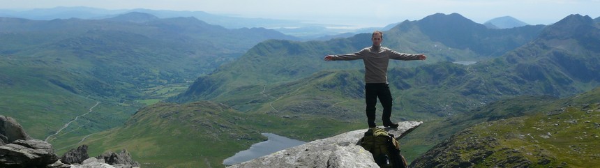
Finally I conquerred Glyder Fach's 994 metres high top. I dropped my backpack and started to jump and crawl around the slabs of rock totally exited, like a kid on a new playground.


I descended along the SE rocky ridge even though there was no path on the map this way and I planned to do this leg towards SW. Anyway, this choice was just as good as the other in the beautiful surroundings, however I made my already quite lengthy trip several kilometres longer for today.


At some places my path lead through almost vertical rock faces but I was quickly down at the altitude of Ffynnon Lloer lake, then I continued my descent along the Afon Lloer river originating from this lake down to Llyn Ogwen lake. Along the way I replenished my water and also took a morning "bath".

rock wall ahead

rock wall behind


Ffynnon Lloer lake

heather

where I started

water collecting spot

Afon Lloer river


morning bath


Once I reached the lake I headed towards W following the shore of the lake.


This section was extremely boggy and wet but fortunately I got easily distracted from this by the view. It became very clear that this area is not in short supply of waterfalls.


almost at the Rhaeadr Ogwen waterfall
Reaching the corner of the lake I checked out Rhaeadr Ogwen waterfall from the most possible angles then I had a coffee break in the tourist centre ... well, more like a cafe only, the rest seemed to be rather shut down. The coffee was majestic.


Rhaeadr Ogwen waterfall


Without the hump on my back I walked around the place and was really glad to find that the real time weather forecast table didn't show any rain for today nor tomorrow. With huge impulse I was on my way again, I started to feel annoyed by the crowd at the cafe anyway. Up until I left the shores of Llyn Idwal lake I had way too many ramblers around me.

Llyn Idwal lake


on the shore of Llyn Idwal lake

Llyn Idwal lake

on the way towards Y Garn, looking at my sleeping summit Pen yr Ole Wen from yesterday

On top of Y Garn, the 3 lakes: Llyn Ogwen, Llyn Idwal, Llyn Clyd
To achieve this great time I had a bunch of help from the weather as it started to rain with howling wind and that made my usual staring into the distance schedule impossible. On the Y Garn (947 m) summit I shot a picture, put on all my waterproofs, sad good by to a group training for trip in Peru, then I was on my way downhill, especially that standing around wasn't an option if you weren't keen on loosing a couple of limbs to frostbite.

on top of Y Garn in pouring rain while putting on my clothes
I passed Devil's Kitchen that was part of my original route, then I started my next ascent of 300 metres after leaving Llyn Cwn lake.

Devil's Kitchen

Devil's Kitchen from above

Llyn Cwn lake, the next summit Glyder Fawr in the background

Llyn Cwn lake, the previous summit Y Garn in the background
The terrain itself was horrific, loose scree, steep gradient and obviously the rain and wind made it even worse. There was nothing to do but to trudge ahead, so that's exactly what I did.

uphill scree

path in retrospect
After 40 minutes of this I was surrounded completely by fog again, so it was an amazing help that i could follow the cairns along the barely visible path up to the summit, which lay only 20 minutes from here.

crossing the fog following the cairns towards the summit


The magical phenomenon from yesterday happened today as well within a short time, that is the wind drove away the fog and even the sun shone through the clouds from time to time, hence I got a clear view of almost the whole Glyder Fawr (1001 m).

disappearing fog


Even Snowdon peeked out from the clouds.

unveiling Snowdon
I got completely soaked by the rain so I needed to keep moving and continued my way to Glyder Fach.


Tryfan
This part of the Glyderau range was completely dominated by bleak, odd forms. I thought one of Glyder Fach's summits, Castell y Gwynt (972 m) to be the final summit (right middle), so I climbed it with great haste this 16 metres high rock tower. On the roughly 1 square metre top I realised Glyder Fach to be still ahead of me but I was content not to have missed this one either.

Castell y Gwynt


Castell y Gwynt on the right, the nearer summit


on the needle sharp top of Castell y Gwynt
Some ramblers arriving behind me took a good look at the tower of rocks then decided to go around it.

looking back at Castell y Gwynt (see the hiker for ratios)

on Glyder Fach's summit, Snowdon in the background


Cantilever Stone

I was horrified looking at the hikers on the Tryfan, especially that I knew the weather conditions they endured on their way up there.

Tryfan

top section of Tryfan

Tryfan's summit
After an other bit of rock climbing I started my descent into Llanberis Pass on the Miner's Track, towards Snowdon.


crossing a boggy area on the Miner's track

waterfall crossing the path, tomorrow's goal Snowdon in the background


Snowdon's foot
Close to the end of this section I had a bit of rest at the side of a fence along with a group of other hikers. After the usual mutual itinerary exchange they really decried my plan to conquer Snowdon. My route was partly on the Watkin path and I was told it's way too long with too much scramble. Anyway, I'm much more headstrong than a couple of experienced hikers familiar with the area could deter me from my plans, so I was happily on my way as originally planned. I note here this route proved to be really long and and some say it's the most demanding route.

Glyders already behind

civilization


All afternoon I've been walking along the southern foot of Snowdon passing Afon Glaslyn river and Llyn Gwynant lakes.


I passed two camp sites where bustling like in a city park in sunny weather. This reassured me that wild camping was the right choice.


I've already been walking on this route when I disrupted a couple having their supper in a camp site, so they could poke at the place on the map where they thought we were. As a result I found out I was still on the right route, I was simply impatient to turn onto the final stretch. I found this rather normal around 8 pm considering the fact my planned sleeping pitch lay somewhere around 700 metres height and at present I was only at 100 metres. But after this I walked along beautiful waterfalls in the right direction, I was also in a hurry not to get caught in darkness somewhere on my way.


Above the waterfall leaving the river I was walking on a pleasant, level, man-made track for a short while but I couldn't find anywhere the path taking me to the ridge from here. So I left the track at the assumed correct place and keeping towards west I crossed everything and found the path shortly, which was more like a sheep track, but I found it. Climbing up to the ridge by this path I had phone service for the first time today, so I was able to send word of my continued existence. I found a sleeping pitch with plenty of disadvantages mainly because it was getting quite dark by the time I started it. The wind blew from many directions, so in order to have a decent night I collected rocks to fix the top of my shelter at the open side to the ground. For this I needed several tens of kilograms of rock. During the night there was plenty of stormy wind and rain but in spite of this I had a good night sleep almost up until 6 am.


Snowdon

Afon Glaslyn river


hydroelectric power plant


building sized boulder

crowded camp site

Llyn Gwynant lake


incline and mining building ruins, waterfall


waterfalls and mining ruins

sleeping pitch, the weighing stones prepared in front of the shelter