Before departure
I finally made up my mind to fix the exact date of my long planned mountain hike for a weekend at end of July.
Many arguments supported this decision, amongst many others the yearly precipitation minimum and temperature maximum, longest days of the year, also out of the 4 days 2 were supposed to be not exclusively rainy and that was relatively decent. This last bit is probably weird but having kept a close eye on the detailed weather forecast for the last 2 months I was able to call that good weather. If you plan a trip into the mountains right next to the ocean, where the average yearly precipitation is around 3000 mm, the question is obviously not if to get soaked but when and how badly.
Many arguments supported this decision, amongst many others the yearly precipitation minimum and temperature maximum, longest days of the year, also out of the 4 days 2 were supposed to be not exclusively rainy and that was relatively decent. This last bit is probably weird but having kept a close eye on the detailed weather forecast for the last 2 months I was able to call that good weather. If you plan a trip into the mountains right next to the ocean, where the average yearly precipitation is around 3000 mm, the question is obviously not if to get soaked but when and how badly.
By this time I got hold of and managed to test almost all the gear on my list. I needed a better pair of boots after my last trip and made some last minute changes in the high energy foodstuff department. I didn't want to admit the necessity of a tent, so I bought a lightweight shelter instead you couldn't close on one side. This hasn't always proved to be the best choice during the trip exactly because of the fact it was open and you couldn't isolate yourself from the elements outside. On the other hand it was only 1100 grams and that was amazingly attractive before departure.
I got all the maps, compass, the long planned and many times replanned itinerary, bus tickets booked and printed, gear waterproofed, bag packed. It was really scary the planning ended and in 2 days it was time to set off.
I got all the maps, compass, the long planned and many times replanned itinerary, bus tickets booked and printed, gear waterproofed, bag packed. It was really scary the planning ended and in 2 days it was time to set off.
Summary:
Distance: 70.34 km
Total ascent: 5123.6 m
Maps (Ordnance Survey):

The way there
Bag packed, everything checked. It got very heavy at the end, 17.1 kgs.


During my last 3 day long trip with 14 kgs on my back it was quite difficult to keep going and that was on flat ground.
Fortunately my bag now held a day's worth of food that only the bus was to carry and a chunky bicycle lock I was to leave at the bus station.
So I got on my bicycle and shot off to the coach station in bright sunshine wearing some of my mountain gear and carrying the rest on my back and by doing so making some of the people smile at the sight of me ... boogeyman in daylight.

bye-bye Southampton
Here I got on the coach to London, then 3 hours later I was on the one to Bangor heading straight to Snowdonia. Obviously the coach broke down and the replacement's driver thought it a good idea to use the the bus as a sauna even though the passengers told him otherwise. Finally we arrived to Bangor in North Wales about 1.5 hours delayed.
Why public transport? Because you get some rest on the way (in theory), takes me exactly to the right place and it's inexpensive.
Why public transport? Because you get some rest on the way (in theory), takes me exactly to the right place and it's inexpensive.
The Trip, 1st day
Summary:
Distance: 30.03 km
Total ascent: 1825.3 m
Maps (Ordnance Survey):


The wind drove the rain horizontally into our faces as we were getting off the coach around 1.30 am, but in spite of this it was a great feeling to escape after 12 hours on buses. Immediately I put on all my wet weather gear in the 24hr Tescos right next to the bus stop and having exchanged a couple of words with the guys from the same bus I set off to my camping pitch at the foot of the mountains.
Despite the continuously reappearing drizzle crossing the calm outskirts and fields of Bangor was a pleasant activity even in darkness. Then it started raining cats and dogs so there was no other option but to pull my hood tighter and trudge on through the remaining 7.5 kms.
Despite the continuously reappearing drizzle crossing the calm outskirts and fields of Bangor was a pleasant activity even in darkness. Then it started raining cats and dogs so there was no other option but to pull my hood tighter and trudge on through the remaining 7.5 kms.


Crossing the A road south of the town I started my ascent first on a tiny forest road then through pastures. The former was an adequate warm up for this area, as it had 16% elevation in almost pitch black, so I was hardly able to see my own boots. The track after this section crossed fields, so by the time I got to my sleeping pitch I scared off hundreds of dumbfounded sheep. By this time even the rain got exhausted and I walked with the guide of a bit of moonshine to the stone sheepfold, where I managed to make camp by 3.30 am. I didn't need any sleeping aid, I was fast asleep for the next 2.5 hours straight.
Instead of the usual alarm clock I was woken by howling orders of the local farmer driving a quad bike. On the countryside people tend to wake up early, especially the farmers apparently. So this wake up alarm was nothing else but the communication between the dog and the farmer, which proved to be extremely efficient at kicking me off my shelter.

substitution alarm clock

morning view
Having shot my pictures of the area I packed, ate breakfast then I was on the move.

sleeping pitch


breakfast

sleeping companions

Penrhyn castle

crossing over the fence


Bangor on the left, the starting point from yesterday

Conwy Bay


What could be the dominant wind direction around here?
(there's no wind present here)

coastal mountains
Leaving the coastal section the path turned towards SE in the direction of the 2 well-known waterfalls at the foot of Carneddau mountain range.


The more famous Aber Falls (Rhaeadr-fawr) is a 37 m high drop of the river Afon Goch and the Rhaeadr-bach which is more a cascade of small waterfalls.

next 2 stops: Rhaeadr-bach (right) and Aber Falls (Rhaeadr-fawr) (left)

Aber Falls

Rhaeadr-bach


Rhaeadr-bach waterfall


Aber Falls waterfall

waterfall about 10 metres behind me


Having basked in the beauty of these I started to climb along Afon Goch towards the mountain ridge. A short initial section lead through scree and rocky bits then above the level of the Aber Falls the terrain changed to rough grassland with heather and mountain vegetation and it remained the same up until I reached the rocky ridge.


ascending the initial scree


above the top of the Aber Falls

thistle

valley of Afon Goch river
Here the good weather ended and the wind and rain started to test if I prepared properly for my trip.
The river running right next to me was more like a series of waterfalls:


Uphill:

remains of an ancient settlement


I seem to be heading into the wrong direction, the sun is shining along the coast

peat hole
I crossed the open, trackless terrain in heavy rain in 3.5 hours and I stood on the first summit on the ridge, Foel-fras (942 m), and actually in the last 40 minutes there was no rain at all. On this spot behind the stone fence I made camp in a hurry to escape the next wave of the rain that arrived in minutes.


After I ended this process with more or less success I broke camp and started heading along the boundary line of Gwynedd and Conwy in the lee of the stone wall.

Unfortunately the stone fence turned towards SE and I didn't expect this to happen. Continuing towards the S in thick fog I stood without any distinct feature in sight in minutes. I sorted out this situation after a bit of panic, intense searching on the map and repeated turning of my compass and I found my way by crossing the boggy terrain. I really appreciated this track even though it looked more like a brook at that moment.

the track

Keeping my bearing in a bit more than 15 minutes I arrived to the 2nd summit: Garnedd Uchaf (926 m).


at Garnedd Uchaf
Here I was welcomed by thick fog but as I started to wander around the rocks the fog started to lift and within 5 minutes it was completely gone. The nearby mountains started to emerge and this allowed me to grasp that I was indeed in the mountains. On top of the strong wind's ability to lift the fog it proved to have an other very useful attribute, to dry your clothes, which I relied upon frequently later on.


Since the waterfalls this was the first time I've seen an other human being, on the summit trying to capture the scenery.


I identified the road ahead towards the next stop Foel Grach (976 m) and after about half an hour of gazing I was off again. Between the two summits lay a wetter vale with the usual amount of sheep loitering around.

between the 2 summits

wind power station on sea
Emergency shelter near Foel Grach. It's not really alluring inside, so you probably wouldn't want to use it in any other situation.

emergency shelter

After a quick look around I was up at 976 metres, and after the mandatory summit shot I was heading Carnedd Llewelyn (1,064 m), so I'll finally break that 1000 m threshold.


on top of Foel Grach
Here I had a longer rest and was immersed in the scenery while eating.


Conwy Bay from a bit higher than in the morning

on top of Carnedd Llewelyn

Carnedd Dafydd and the ridge leading to it

shelter on Carnedd Llewelyn


black sheep

From here on until I reached Carnedd Dafydd (1,044 m) the ridge and the view was really dramatic, on the northern side half a kilometre below the sheer rocky wall run Afon Llafar river lit by the afternoon sunshine, to the south Ffynnon Llugwy reservoir ornamented on the area.

Afon Llafar river


Ffynnon Llugwy reservoir

camping pitch with view

the way forward

Before I reached today's terminal point Pen yr Ole Wen (978 m) several sights emerged from the shadow of the mountains, amongst many others Ffynnon Lloer lake, that I visited the following day, Tryfan looking like a chocolate summit cake only with a bit more rocks, the Llyn Bochlwyd lake ending in a waterfall and the famous Snowdon summit.

Llyn Bochlwyd lake

Tryfan

looking back


Ffynnon Lloer lake

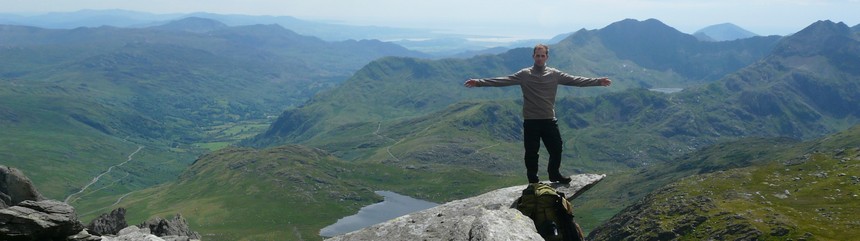
veiled Snowdon

on Pen yr Ole Wen's summit
At the cairn op the summit I dropped my heavy gear and within 10 minutes I found a superb sleeping pitch. I was able to set up camp half sheltered by a slab of rock, so I had an enlarged living space instead of the otherwise cramped shelter. Before going to sleep I hang most of my staff letting them dry a bit.


At dawn there was a nice little rain but I wasn't bothered, in the shelter of my solid rocks I slept through the whole thing and later on half asleep I was listening if it stopped, then came out of my cave to start a new busy day.

morning stretches with view

